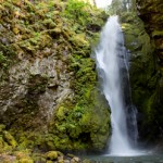
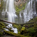
Pinard Falls is a breathtaking 105 ft. waterfall on Layng Creek near Cottage Grove, Oregon, in the Row River Drainage. This unique waterfall squeezes and twists through a narrow notch carved in the bedrock before it plunges into a picturesque pool surrounded by mossy basalt walls. Open almost year round, the falls are accessed via a 1/2 mile hike (one way) through the Umpqua National Forest. Pinard Falls are definitely worth the time involved and hiking to nearby Spirit and Moon Falls make a great full day adventure! Location: Pinard Falls … [Read more...]
Spirit Falls – Hiking and Photography
July 7, 2012 By
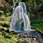
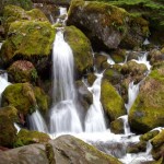
Spirit Falls is a gorgeous 40ft channeled waterfall, flowing over moss covered rock on Alex Creek near Cottage Grove, Oregon. Accessible year round at an elevation of 1900 ft and only a 2/3rd mile round trip day hike, Spirit falls is a great adventure for the whole family. Spirit Falls and nearby Moon Falls and Pinard Falls make a great full day adventure! Location: Spirit Falls is located approximately 50 miles from Eugene, on Forest Service Road #1790 off Layng Creek Road (FS Road #17) outside of Cottage Grove, Oregon. The trailhead is … [Read more...]
Toketee Falls – North Umpqua River
April 19, 2012 By
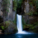
Toketee Falls is a breath taking two stage 113ft. waterfall located about 2-1/2 hours Southeast of Eugene (less than one hour east of Roseburg) just off of highway 138. The water plunges over picturesque mossy volcanic columnar basalt into the North Umpqua River near its confluence with the Clearwater River. The first stage of Toketee falls is somewhat difficult to view and falls 28 feet into a narrow shaded alcove. The main and more attractive section of waterfall plunges about 85 feet into a gorgeous rock lined blue pool. Location: Toketee … [Read more...]
Newberry Volcanic Monument – Paulina and East Lake
January 17, 2012 By
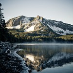
Newberry Volcanic Monument - Officially created in 1990 within the Deschutes National Forest, Newberry Crater is a 17sq mile geologic wonder. The monument contains lakes stocked with fish, cinder cones, obsidian flows, waterfalls, camping, hiking and even some elusive hot springs if you know where to look for them. It's two main lakes, Paulina Lake and East Lake are surrounded by lush forests ands amazing peaks. The access road is seasonal and it is not uncommon for it to be blocked until after Memorial Day. The Location: Paulina Lake (the … [Read more...]
Proxy Falls – McKenzie Highway
October 24, 2011 By
Proxy Falls is a gorgeous 226 foot veil waterfall that cascades down a wall of mossy columnar basalt. Accessed by a short half mile to mile hike directly off McKenzie Highway 242, Proxy Falls is easily one of the most photogenic waterfalls in Oregon. Location: Proxy Falls is located approximately 65 miles from Eugene, 6-1/2 miles from the junction of Highway 126 (The McKenzie River Byway) and Highway 242 (McKenzie Pass). The parking area is well signed with a large pull out right before the road turns sharply and gains significant … [Read more...]
Triangle Lake Slide Rock – Lake Creek Falls, Oregon
August 12, 2011 By
Slide Rock at Lake Creek Falls near Triangle Lake is a unique natural water slide, swimming hole, and cliff jumping area located near Junction City, Oregon, approximately 50 minutes from Eugene. At the entrance to the recreation area, a small waterfall empties into a quaint swimming hole, with a cliff jumping area located directly across the creek. The cliff jumping features dangling ropes and multiple jumping platforms at 25 and 35 feet. The water below is plenty deep, but USE CAUTION. Further down the creek from the waterfall and pool are the … [Read more...]
Watson Falls
April 8, 2010 By
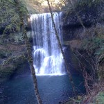
One of the highest waterfalls in Oregon, Watson Falls plunges 272 feet to its moss-covered base, and is an easy 0.8 mile hike round-trip with a 300 foot elevation gain. Located along Highway 138, Watson Falls is one of a string of waterfalls whose trail heads are easily accessed from the highway, and is a quick stop during any trip through the area. Location: Google Maps - Eugene to Watson Falls Getting There From Roseburg, take Highway 138 for approximately 61 miles. Turn south on Road 37, and park at the trail head parking lot … [Read more...]
Tamolitch Pool
April 3, 2010 By
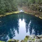
Tamolitch Pool (also known as Blue Pool) is the basin of Tamolitch Falls, once a natural waterfall on the McKenzie River that has since been diverted by EWEB, buried by lava flows, and is now a "dry" waterfall. What remains is a large, breathtaking pool of spring-fed water that shades from deep purple to turquoise. The Trailhead: The trail to Tamolitch Pool (near Blue River, Oregon) leaves from a trail head a few hundred yards off of Highway 126, and is a four mile loop along part of the popular 26-mile-long McKenzie River Trail. For the … [Read more...]
Koosah Falls
March 24, 2010 By
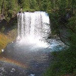
Koosah Falls is a Beautiful 80ft. waterfall located 75 minutes outside of Eugene on highway 126. The word Koosah is a Chinook word meaning "sky". These falls were formed 3,000 years ago when lava flows formed the McKenzie River. Location: Koosah falls is located approximately 60 miles outside Eugene directly off highway 126. There are visible signs on the side of the road. Google Maps - Eugene to Koosah Falls - Click Here for the Map Adventure Specifics: The waterfall is easily accessible via a paved path from the parking lot. The are … [Read more...]
Silver Falls State Park – Waterfalls, Hiking, Swimming
March 24, 2010 By
Silver Falls State Park is known for it's ten gorgeous waterfalls it's many miles of hiking trails. Located 45 minutes outside Salem on Highway 214. Location: Eugene to Silver Falls - Google Maps Links to External Sites: Silver Falls State Park Main Page Great Park Picture Resource ***More to come*** … [Read more...]