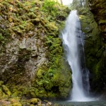
Pinard Falls is a breathtaking 105 ft. waterfall on Layng Creek near Cottage Grove, Oregon, in the Row River Drainage. This unique waterfall squeezes and twists through a narrow notch carved in the bedrock before it plunges into a picturesque pool surrounded by mossy basalt walls. Open almost year round, the falls are accessed via a 1/2 mile hike (one way) through the Umpqua National Forest. Pinard Falls are definitely worth the time involved and hiking to nearby Spirit and Moon Falls make a great full day adventure! Location: Pinard Falls … [Read more...]
Tire Mountain – Hiking & Wildflower Meadows
July 7, 2012 By
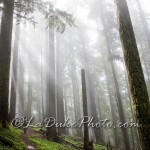
Tire Mountain outside of Oakridge, Oregon is a relatively easy 7.6 mile round trip hike through old growth forests and sloping meadows filled with seasonal wildflowers. Mid-June through mid-July will provide the best variety of wildflowers. Tire Mountain was once home to a small fire lookout, now all that remains is the cleared spot on the top of the mountain. Since its decommissioning, trees and brush have overgrown the clearing obstructing all views from the top. This trail is open to hikers and bikers so be prepared to share the … [Read more...]
Spirit Falls – Hiking and Photography
July 7, 2012 By
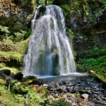
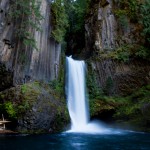
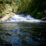
Spirit Falls is a gorgeous 40ft channeled waterfall, flowing over moss covered rock on Alex Creek near Cottage Grove, Oregon. Accessible year round at an elevation of 1900 ft and only a 2/3rd mile round trip day hike, Spirit falls is a great adventure for the whole family. Spirit Falls and nearby Moon Falls and Pinard Falls make a great full day adventure! Location: Spirit Falls is located approximately 50 miles from Eugene, on Forest Service Road #1790 off Layng Creek Road (FS Road #17) outside of Cottage Grove, Oregon. The trailhead is … [Read more...]
Mt. Pisgah Arboretum – Hiking, Festivals, Gardens
June 19, 2012 By
Mt. Pisgah Arboretum is a beautiful 209-acre arboretum located between Eugene and Springfield, Oregon on the banks of the Willamette River. Full of miles of hiking trails and nature paths, Mt. Pisgah and the surrounding Howard Buford Recreation Area are best known for their diverse wildlife, expansive gardens, and unique habitats. There are several trails along the Willamette River, across the wildflower meadows, through the evergreen forests, and around the stunning water garden. Location: Mt. Pisgah arboretum is located in Lane County, … [Read more...]
Delta Ponds – Bird Watching and Nature Walk
May 7, 2012 By

Known for their fantastic wildlife viewing, birdwatching, wildflowers, and nearby running and biking trails, the Delta Ponds are one of Eugene, Oregon's most well known casual recreation areas. The area is a 150 acre network of ponds, sloughs, and waterways near Valley River Center that act as a major haven for wildlife of all kinds. Over 100 species of birds have been recorded at Delta Ponds and the adjacent stretches of the Willamette River along with numerous fish and aquatic wildlife, including the threatened Western Pond … [Read more...]
Toketee Falls – North Umpqua River
April 19, 2012 By
Toketee Falls is a breath taking two stage 113ft. waterfall located about 2-1/2 hours Southeast of Eugene (less than one hour east of Roseburg) just off of highway 138. The water plunges over picturesque mossy volcanic columnar basalt into the North Umpqua River near its confluence with the Clearwater River. The first stage of Toketee falls is somewhat difficult to view and falls 28 feet into a narrow shaded alcove. The main and more attractive section of waterfall plunges about 85 feet into a gorgeous rock lined blue pool. Location: Toketee … [Read more...]
Newberry Volcanic Monument – Paulina and East Lake
January 17, 2012 By
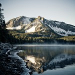
Newberry Volcanic Monument - Officially created in 1990 within the Deschutes National Forest, Newberry Crater is a 17sq mile geologic wonder. The monument contains lakes stocked with fish, cinder cones, obsidian flows, waterfalls, camping, hiking and even some elusive hot springs if you know where to look for them. It's two main lakes, Paulina Lake and East Lake are surrounded by lush forests ands amazing peaks. The access road is seasonal and it is not uncommon for it to be blocked until after Memorial Day. The Location: Paulina Lake (the … [Read more...]
Umpqua Lighthouse and State Park
January 17, 2012 By
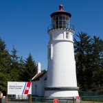
Umpqua Lighthouse and State Park is an easily accessible and popular general recreation area located less than 100 miles west of Eugene and a short 12 minute drive from Reedsport. The area is known for the 65 foot lighthouse that overlooks Winchester Bay. With its famous red light, the Umpqua Lighthouse is the only lighthouse on the Oregon Coast with a colored light. It was put into operation in 1894 after the prior lighthouse at that location (the first lighthouse in Oregon) fell into the river due to erosion after a short 7 year … [Read more...]
Proxy Falls – McKenzie Highway
October 24, 2011 By
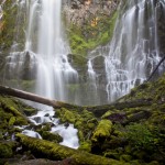
Proxy Falls is a gorgeous 226 foot veil waterfall that cascades down a wall of mossy columnar basalt. Accessed by a short half mile to mile hike directly off McKenzie Highway 242, Proxy Falls is easily one of the most photogenic waterfalls in Oregon. Location: Proxy Falls is located approximately 65 miles from Eugene, 6-1/2 miles from the junction of Highway 126 (The McKenzie River Byway) and Highway 242 (McKenzie Pass). The parking area is well signed with a large pull out right before the road turns sharply and gains significant … [Read more...]
Triangle Lake Slide Rock – Lake Creek Falls, Oregon
August 12, 2011 By
Slide Rock at Lake Creek Falls near Triangle Lake is a unique natural water slide, swimming hole, and cliff jumping area located near Junction City, Oregon, approximately 50 minutes from Eugene. At the entrance to the recreation area, a small waterfall empties into a quaint swimming hole, with a cliff jumping area located directly across the creek. The cliff jumping features dangling ropes and multiple jumping platforms at 25 and 35 feet. The water below is plenty deep, but USE CAUTION. Further down the creek from the waterfall and pool are the … [Read more...]