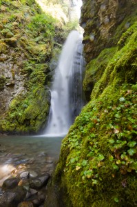
Pinard Falls is a breathtaking 105 ft. waterfall on Layng Creek near Cottage Grove, Oregon, in the Row River Drainage. This unique waterfall squeezes and twists through a narrow notch carved in the bedrock before it plunges into a picturesque pool surrounded by mossy basalt walls. Open almost year round, the falls are accessed via a 1/2 mile hike (one way) through the Umpqua National Forest. Pinard Falls are definitely worth the time involved and hiking to nearby Spirit and Moon Falls make a great full day adventure!
 Location: Pinard Falls is located approximately 53 miles from Eugene, on Forest Service Road #1790 off Layng Creek Road (FS Road #17) outside of Cottage Grove, Oregon. The trailhead is well marked and while some of the road is gravel, it is easily accessed by most vehicles. While the trailhead for the falls can be access from Highway 58 (Oakridge Area), I highly recommend taking the route from Cottage Grove (mapped below) as it is paved almost all the way to the falls trailhead.
Click Here for detailed step-by-step directions – Directs to Bottom of Page
Google Maps: – Eugene to Pinard Falls
Adventure Specifics: Pinard Falls is accessed by a clearly marked and signed trailhead/pullout approx 3.6 miles up Forest Service Road #1790 (marked for Spirit, Moon, and Pinard Falls at the beginning). Parking is available at a large pullout big enough for 5-10 vehicles.
The Pinard Falls hiking trail starts on an old logging road before turning into trail #1406. It’s 1/2 mile flat to downhill hike through thinned forests with the occasional wildflower meadow. The trail gets somewhat steep and muddy in a few spots, but most people should have no trouble navigating it. As you approach the falls, the trail widens into a small viewing platform. Most people stop here, but the adventurous can continue down a very steep trail to the base of the falls for a different perspective.
The falls were discovered by timber prospectors many years ago, but weren’t accessible to the public until the forest service and volunteers built the trail in Spring of 2007. The completion of the trail marked a momentous occasion as it was the first trail in 12 years to be opened in the Umpqua National Forest.
Photography Tips: Pinard Falls is shaded most of the day, making it a great candidate for photographers. However, getting the proper angle on these falls is very tricky and the foreground is usually sunny. I’d highly recommend bringing a tripod and be prepared to get close to the falls for an evenly exposed shot.
Warnings: The path can be fairly muddy year round. During the winter months the paths around the falls can be snowy and icy. Use caution. Pinard Falls is located within the Layng Creek Watershed (the water supply for Cottage Grove). Please respect and protect the water supply by following the No Camping and No Swimming Regulations within the Layng Creek Watershed.
What to Bring: A camera, water resistant jacket (if you plan on getting near the falls), and good walking/hiking shoes.
Time Involved: We recommend setting aside at least an hour to hike down and enjoy the falls. Be sure to check out nearby Spirit and Moon Falls.
Amenities: NO AMENITIES. No garbage receptacles. Pack it in, Pack it out!
Best Times to Go: Pinard Falls are generally open year round, but Spring and early Summer are the best due to higher water flows. Access to the falls may be closed off in the winter months due to low elevation snow. Consult with Cottage Grove Ranger Station (541-767-5000) or the US Forestry Department in Cottage Grove (541-942-5591) for status of Forest Service Roads #17 and #1790 before travel.
Nearby: Spirit Falls, Moon Falls, Bohemia Mountain, Wildwood Falls
Detailed Step-By-Step Directions: (Directions taken from resource (1) below)
Spirit Falls is east of Cottage Grove.
GPS N43º 43.844?, W122º 38.487?, Elevation above sea level 2800 ft.
- Take Cottage Grove exit 174
- Head east on Row River Road
- Past milepost 4 continue straight onto Shoreview Drive
(Row River Rd splits off to the left – Shoreview Drive rejoins Row River Rd in another six miles)- Past milepost 19 Row River Road ends.
- Turn left onto Layng Creek Road (aka Forest Service Road #17)
- About 9 miles later look for Forest Service Road #1790 and turn right.
(signed for Spirit Falls, Moon Falls and Pinard Falls)- Reset your trip odometer
- Go past the wide spot in the road (Spirit Falls access) – in 0.2 miles drive past
the sign that says ‘Moon Falls 3 miles’ – keeping right to stay on #1790 –
and drive for a total of 3.6 miles along #1790.- A Pinard Falls Trailhead sign will be on the right.
- To the left walk up abandoned road 1790-439 (becomes Trail #1406).
- Hiking distance to Pinard Falls is ½ mile.
Resources and References:
(1) – http://www.oregonwaterfalls.net/pinard.htm
http://www.waterfallsnorthwest.com/nws/falls.php?num=3619
http://www.cgsentinel.com/V2_news_articles.php?heading=0&story_id=1071&page=72