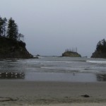
Sunset Bay, OR - The Oregon coastline is world famous for its stunning scenery, and the area south of Coos Bay is no exception. Erosion and seismic action have created a crumbling, fractured coastline full of geologic interest and curious rock formations. Location: Getting There Take 101 through Coos Bay, and turn right onto Empire Rd before you leave town. Take Empire/Coos Bay Hwy for 2.8 miles, then veer left onto Newmark for 0.5 miles, left again to get onto Cape Arago Hwy, and drive for 8 miles. Adventure … [Read more...]
Bohemia Mountain
April 9, 2010 By
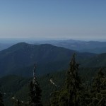
Bohemia Mountain near Cottage Grove in Lane County, Oregon is a 5840’ peak with a nice hike to an incredible 360-degree view of the Cascade Range. Seasonal wildflower viewing, a nearby ghost town, and all-terrain vehicle trails make a trip to this area even more worthwhile. Location: Google Maps – Eugene to Bohemia Mountain - *Approximate trailhead Location Read Below for detailed directions* (N 43.574288 and W -122.656999) – Mountain Coordinates To get there, drive south on I-5 from Eugene, taking Exit 174 at Cottage Grove. At the … [Read more...]
Watson Falls
April 8, 2010 By
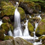
One of the highest waterfalls in Oregon, Watson Falls plunges 272 feet to its moss-covered base, and is an easy 0.8 mile hike round-trip with a 300 foot elevation gain. Located along Highway 138, Watson Falls is one of a string of waterfalls whose trail heads are easily accessed from the highway, and is a quick stop during any trip through the area. Location: Google Maps - Eugene to Watson Falls Getting There From Roseburg, take Highway 138 for approximately 61 miles. Turn south on Road 37, and park at the trail head parking lot … [Read more...]
Tamolitch Pool
April 3, 2010 By
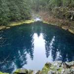
Tamolitch Pool (also known as Blue Pool) is the basin of Tamolitch Falls, once a natural waterfall on the McKenzie River that has since been diverted by EWEB, buried by lava flows, and is now a "dry" waterfall. What remains is a large, breathtaking pool of spring-fed water that shades from deep purple to turquoise. The Trailhead: The trail to Tamolitch Pool (near Blue River, Oregon) leaves from a trail head a few hundred yards off of Highway 126, and is a four mile loop along part of the popular 26-mile-long McKenzie River Trail. For the … [Read more...]
Matthieu Lakes – Dee Wright Observatory
April 3, 2010 By
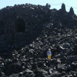
The Matthieu Lakes Trail, located on Highway 242 about 15 miles west of Sisters, Oregon, takes you through a pine forest bordering lava beds up to two small, idyllic lakes, with spectacular views of the North and Middle Sisters, Mt. Washington, Three-Fingered Jack, Mt. Jefferson, and Mt. Hood along the way. Location:Google Maps - Directions from Eugene Approximately 1.5 hours from Eugene, Oregon. To reach the Matthieu Lakes trail head, from I-5 south near Eugene, take OR 126/McKenzie River Highway east for approximately 55 miles, and … [Read more...]