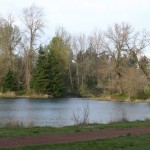
Last week the weather in Eugene was absolutely amazing! Temperatures were warm, the rain was gone, and everyone was outside enjoying what Eugene, Oregon has to offer. I hiked Spencer Butte from both the Fox Hollow and Willamette trail heads last week and it was beautiful! Wildflowers are blooming and the underbrush is thick and green. Spring is definitely the best season to hike up Spencer's. Despite rain the weeks before, the trails are drying quickly and park crews have improved some rocky sections of the upper trail (thank you butte workers … [Read more...]
Bohemia Mountain
April 9, 2010 By
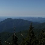
Bohemia Mountain near Cottage Grove in Lane County, Oregon is a 5840’ peak with a nice hike to an incredible 360-degree view of the Cascade Range. Seasonal wildflower viewing, a nearby ghost town, and all-terrain vehicle trails make a trip to this area even more worthwhile. Location: Google Maps – Eugene to Bohemia Mountain - *Approximate trailhead Location Read Below for detailed directions* (N 43.574288 and W -122.656999) – Mountain Coordinates To get there, drive south on I-5 from Eugene, taking Exit 174 at Cottage Grove. At the … [Read more...]
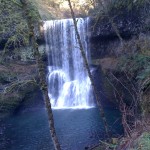
Watson Falls
April 8, 2010 By
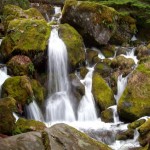
One of the highest waterfalls in Oregon, Watson Falls plunges 272 feet to its moss-covered base, and is an easy 0.8 mile hike round-trip with a 300 foot elevation gain. Located along Highway 138, Watson Falls is one of a string of waterfalls whose trail heads are easily accessed from the highway, and is a quick stop during any trip through the area. Location: Google Maps - Eugene to Watson Falls Getting There From Roseburg, take Highway 138 for approximately 61 miles. Turn south on Road 37, and park at the trail head parking lot … [Read more...]
Tamolitch Pool
April 3, 2010 By
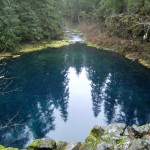
Tamolitch Pool (also known as Blue Pool) is the basin of Tamolitch Falls, once a natural waterfall on the McKenzie River that has since been diverted by EWEB, buried by lava flows, and is now a "dry" waterfall. What remains is a large, breathtaking pool of spring-fed water that shades from deep purple to turquoise. The Trailhead: The trail to Tamolitch Pool (near Blue River, Oregon) leaves from a trail head a few hundred yards off of Highway 126, and is a four mile loop along part of the popular 26-mile-long McKenzie River Trail. For the … [Read more...]
Koosah Falls
March 24, 2010 By
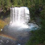
Koosah Falls is a Beautiful 80ft. waterfall located 75 minutes outside of Eugene on highway 126. The word Koosah is a Chinook word meaning "sky". These falls were formed 3,000 years ago when lava flows formed the McKenzie River. Location: Koosah falls is located approximately 60 miles outside Eugene directly off highway 126. There are visible signs on the side of the road. Google Maps - Eugene to Koosah Falls - Click Here for the Map Adventure Specifics: The waterfall is easily accessible via a paved path from the parking lot. The are … [Read more...]
Willamette Pass Ski Resort
March 24, 2010 By
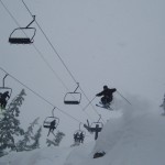
Willamette Pass Ski Resort is a medium sized ski resort located 75 minutes outside of Eugene on Highway 58. Known for it's great steep terrain and proximity to the Eugene Area, Willamette Pass makes a perfect day trip when you're craving the snow. In the summer they have some of the best mountain biking, hiking, and sight seeing in the Cascades. General Comments:Willamette Pass is a great ski resort if you want a fun, convenient day of skiing. They have terrain for everyone, a great atmosphere, and an enjoyable mountain. If you are a … [Read more...]
Crater Lake National Park – General Information
March 24, 2010 By
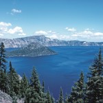
Crater Lake National Park is a United States National Park located in southern Oregon, whose primary feature is Crater Lake. This National Park was established on May 22, 1902, and it is the sixth oldest National Park in the U.S. This park encompasses the Crater Lake caldera, which rests in the remains of a destroyed volcano (eventually named Mount Mazama) and the surrounding forestland and hills. This is the only National Park in Oregon. The lake is 1,949 feet (594 m) deep at its deepest point, which makes it the deepest lake in the … [Read more...]
Silver Falls State Park – Waterfalls, Hiking, Swimming
March 24, 2010 By
Silver Falls State Park is known for it's ten gorgeous waterfalls it's many miles of hiking trails. Located 45 minutes outside Salem on Highway 214. Location: Eugene to Silver Falls - Google Maps Links to External Sites: Silver Falls State Park Main Page Great Park Picture Resource ***More to come*** … [Read more...]
Skinner Butte – Hiking, Views of Eugene
March 24, 2010 By
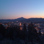
Overview: Skinner's Butte is the large prominent butte on the north edge of downtown Eugene. It was named after Eugene Skinner, the founder of Eugene. It tops out at an elevation of just under 700ft. and offers great views of downtown Eugene, especially at sunset. There are many trails going to the top of Skinner's as well as a paved road to the top. Location: The big hill on the North edge of downtown Eugene. You can't miss it. Google Maps Link to Parking - Click Here for the Map Time Involved: The trails on the North end of the butte … [Read more...]
Heceta Head Lighthouse and State Park
March 24, 2010 By
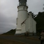
Heceta Head Lighthouse and State Park is a beautiful general recreation area located about 90 minutes outside Eugene and 15 minutes North of Florence. The area is known for it's beautiful views and primarily, Heceta Head Lighthouse. You have likely seen this area many times before in magazines, movies, and on TV. Fees: $3 for day use parking Location: 90 minutes West of Eugene. Take Highway 126 East to Florence and then 101 North to Heceta Head. Eugene to Heceta Head - Click Here for the Map Time Involved: I usually like to make a day … [Read more...]