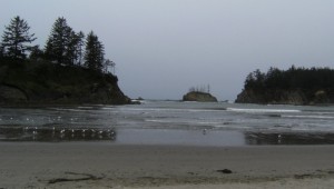
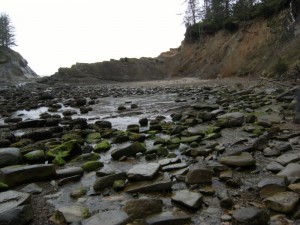
Sunset Bay, OR – The Oregon coastline is world famous for its stunning scenery, and the area south of Coos Bay is no exception. Erosion and seismic action have created a crumbling, fractured coastline full of geologic interest and curious rock formations.
Location:
Getting There Take 101 through Coos Bay, and turn right onto Empire Rd before you leave town. Take Empire/Coos Bay Hwy for 2.8 miles, then veer left onto Newmark for 0.5 miles, left again to get onto Cape Arago Hwy, and drive for 8 miles.
Adventure Specifics:
Sunset Bay is a well-appointed campground, and makes a great base from which to explore the rest of the area. Whether you’ve brought your RV, your tent, or you have reserved a cozy yurt, the campground features a number of pleasant campsites, clean restrooms, and hot showers. Since the campground is set a few hundred yards inland from the beach, it is sheltered from shore winds, and next door to a small golf course. The only word of caution I would mention would be to keep in mind that the campsites are small; if you are looking for privacy and reserving sites online, consider picking the more remote sites, or ones that have no reservations next door. Aside from a squabbling family who left early on our first morning, the campground was fairly peaceful despite it being spring break, and everyone seemed to quiet down soon after dark. The yurts also offer more privacy and act as a better sound barrier than a tent. For more information, go to: http://www.oregonstateparks.org/park_100.php
Shore Acres Less than a mile away by road, or two miles by a scenic trail along the top of the cliffs, Shore Acres is a botanical garden and former estate to lumber baron Louis J. Simpson. While his original mansion fell prey to both shore erosion and the depredations of the Great Depression, the grounds have been lovingly restored and turned into a public park. The park is well designed and features different floral displays and plantings throughout the year to take advantage of different blooming periods. To find out more, go to: http://www.shoreacres.net/
Cape Arago Another two miles by trail, or a shorter distance by road, lies Cape Arago, a jutting promontory and state park. With numerous tide pools and colonies of seals and sea lions, the Cape is a great introduction to the marine wildlife in the area. Come and enjoy the vista and watch for spouting whales, but don’t forget that parts of the trail are off-limits from March 1-June 30 to protect young seals. http://www.oregonstateparks.org/park_94.php
History:
During the Eocene period approximately 40 million years ago, much of the present coastline of Oregon and Washington was below sea level. A long, semicircular bay reaching from the present-day Puget Sound cut inland across much of the Willamette Valley, and curved back around through parts of the present-day Siskiyous. Present-day Coos Bay was not inundated, and marked the edge of the prehistoric bay. The sandstone and shale cliffs and islands around Sunset Bay and Cape Arago were formed by an ancient delta fed by streams from inland Oregon, which deposited mud and silt along the coast. The floor of this delta then hardened over time and was lifted up by the subduction zone off of the Oregon coast. Part of this bedrock is now visible on the beach of Sunset Bay in the large rock formations that jut up out of the sand.
Coal deposits are a feature of this delta, and are now referred to as the Coaledo Formation, Oregon’s largest coal deposits. Coos Bay made much use of this natural resource, opening its first mine in the 1850’s. By 1904 approximately 40 coal mines were operating, selling their coal to fuel locomotives. However, once diesel engines became popular in the 1920’s, the coal mines declined and closed by the 1940’s. Fossilized clams, snails, sand dollars, crabs, logs, and prehistoric plants can be found in the Sunset Bay and Cape Arago cliffs and boulders. The many fault lines that run along this small section of the coast have left their mark on the land.
Erosion in many forms has also carved this landscape: concretions along the Shore Acres observation shelter, wave erosion, honeycomb weathering from salt and algae, and stone-boring marine life. The south side of Sunset Bay reveals evidence of a huge earthquake which struck approximately 1,200 years ago; exposed roots of enormous spruce trees in the intertidal zone show that the coastline dropped rapidly during an earthquake, flooding the forest with salt water. Long before European settlers first spotted Cape Arago in the 1500’s on Sir Francis Drake’s voyage, the Coos Indians inhabited the area, and retain strong ties to Chief’s Island where the decommissioned Cape Arago lighthouse now stands.
Find more photos and information on this post at Andrea’s Blog – Shoestring Traveler

