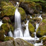
The North Umpqua Trail parallels the N. Umpqua River east of Roseburg, OR for 79 miles of hiking and biking. The Tioga section is the first section you come to when approaching from Roseburg or Glide and it is about 16 miles of aerobically demanding hill climbs to gorgeous views. The trail in predominantly single track and this section ends at Wright Creek. Location: The Trailhead for the Tioga Section (and the start of the N. Umpqua Trail) is at the Swiftwater Picnic Area about 6 miles east of Glide, OR. Time Involved: A couple of hours … [Read more...]
The Painted Hills – Mitchell, Oregon
February 25, 2011 By
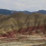
Central Oregon's famous Painted Hills were born in a fiery cloud of ash approximately 33 million years ago and are a spectacular display of the colors of nature’s palette. A series of low clay hills striped in bands of orange, red, black, green, blue, and lavender, the Painted Hills invite visitors to explore the fragile area with designated hiking trails and interpretive signs. History: The unique colors of the Painted Hills were formed by volcanic eruptions that sent clouds of ash to settle over much of Central Oregon. Over time, … [Read more...]
Sunset Bay and Shore Acres
April 13, 2010 By
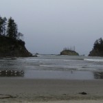
Sunset Bay, OR - The Oregon coastline is world famous for its stunning scenery, and the area south of Coos Bay is no exception. Erosion and seismic action have created a crumbling, fractured coastline full of geologic interest and curious rock formations. Location: Getting There Take 101 through Coos Bay, and turn right onto Empire Rd before you leave town. Take Empire/Coos Bay Hwy for 2.8 miles, then veer left onto Newmark for 0.5 miles, left again to get onto Cape Arago Hwy, and drive for 8 miles. Adventure … [Read more...]
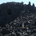
Bohemia Mountain
April 9, 2010 By
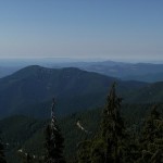
Bohemia Mountain near Cottage Grove in Lane County, Oregon is a 5840’ peak with a nice hike to an incredible 360-degree view of the Cascade Range. Seasonal wildflower viewing, a nearby ghost town, and all-terrain vehicle trails make a trip to this area even more worthwhile. Location: Google Maps – Eugene to Bohemia Mountain - *Approximate trailhead Location Read Below for detailed directions* (N 43.574288 and W -122.656999) – Mountain Coordinates To get there, drive south on I-5 from Eugene, taking Exit 174 at Cottage Grove. At the … [Read more...]
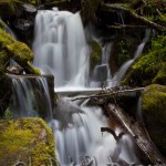
Watson Falls
April 8, 2010 By
One of the highest waterfalls in Oregon, Watson Falls plunges 272 feet to its moss-covered base, and is an easy 0.8 mile hike round-trip with a 300 foot elevation gain. Located along Highway 138, Watson Falls is one of a string of waterfalls whose trail heads are easily accessed from the highway, and is a quick stop during any trip through the area. Location: Google Maps - Eugene to Watson Falls Getting There From Roseburg, take Highway 138 for approximately 61 miles. Turn south on Road 37, and park at the trail head parking lot … [Read more...]
Tamolitch Pool
April 3, 2010 By
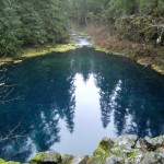
Tamolitch Pool (also known as Blue Pool) is the basin of Tamolitch Falls, once a natural waterfall on the McKenzie River that has since been diverted by EWEB, buried by lava flows, and is now a "dry" waterfall. What remains is a large, breathtaking pool of spring-fed water that shades from deep purple to turquoise. The Trailhead: The trail to Tamolitch Pool (near Blue River, Oregon) leaves from a trail head a few hundred yards off of Highway 126, and is a four mile loop along part of the popular 26-mile-long McKenzie River Trail. For the … [Read more...]
Matthieu Lakes – Dee Wright Observatory
April 3, 2010 By
The Matthieu Lakes Trail, located on Highway 242 about 15 miles west of Sisters, Oregon, takes you through a pine forest bordering lava beds up to two small, idyllic lakes, with spectacular views of the North and Middle Sisters, Mt. Washington, Three-Fingered Jack, Mt. Jefferson, and Mt. Hood along the way. Location:Google Maps - Directions from Eugene Approximately 1.5 hours from Eugene, Oregon. To reach the Matthieu Lakes trail head, from I-5 south near Eugene, take OR 126/McKenzie River Highway east for approximately 55 miles, and … [Read more...]
Koosah Falls
March 24, 2010 By
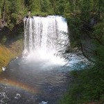
Koosah Falls is a Beautiful 80ft. waterfall located 75 minutes outside of Eugene on highway 126. The word Koosah is a Chinook word meaning "sky". These falls were formed 3,000 years ago when lava flows formed the McKenzie River. Location: Koosah falls is located approximately 60 miles outside Eugene directly off highway 126. There are visible signs on the side of the road. Google Maps - Eugene to Koosah Falls - Click Here for the Map Adventure Specifics: The waterfall is easily accessible via a paved path from the parking lot. The are … [Read more...]
Willamette Pass Ski Resort
March 24, 2010 By
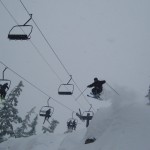
Willamette Pass Ski Resort is a medium sized ski resort located 75 minutes outside of Eugene on Highway 58. Known for it's great steep terrain and proximity to the Eugene Area, Willamette Pass makes a perfect day trip when you're craving the snow. In the summer they have some of the best mountain biking, hiking, and sight seeing in the Cascades. General Comments:Willamette Pass is a great ski resort if you want a fun, convenient day of skiing. They have terrain for everyone, a great atmosphere, and an enjoyable mountain. If you are a … [Read more...]
Silver Falls State Park – Waterfalls, Hiking, Swimming
March 24, 2010 By
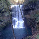
Silver Falls State Park is known for it's ten gorgeous waterfalls it's many miles of hiking trails. Located 45 minutes outside Salem on Highway 214. Location: Eugene to Silver Falls - Google Maps Links to External Sites: Silver Falls State Park Main Page Great Park Picture Resource ***More to come*** … [Read more...]